
Overview
The Export Point Group to KML tool in SPCAD allows users to export survey point data directly into KML (Keyhole Markup Language) format, fully compatible with Google Earth and other geospatial visualization software. This feature helps engineers, surveyors, and GIS professionals view terrain data, elevation points, and project layouts in a realistic 3D environment.
Using this tool, you can easily share geospatial data with clients or teams who do not use CAD or GIS software, ensuring smooth collaboration and accurate visual communication.
Features
Each exported point is represented as a Placemark in Google Earth, providing clear visualization and detailed information.
- The tool automatically includes the following attributes for every point:
- Coordinates (Longitude, Latitude, Elevation) — ensures accurate spatial positioning in 3D space.
- Name (Point Number) — displays the point ID for easy identification.
- Description (if available) — adds field notes or location details.
- Altitude (Z Value) — supports true 3D representation for terrain visualization.
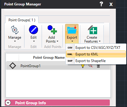
Additionally, the exported KML file can be directly opened in Google Earth, ArcGIS Earth, or other KML-compatible platforms, making it ideal for reviewing site data and communicating design intent visually.
Use Cases
The Export Point Group to KML tool is useful in a variety of survey and geospatial applications:
- Visualizing terrain or survey points directly in Google Earth for analysis and reporting.
- Presenting project data to clients or stakeholders who do not use CAD/GIS tools.
- Overlaying survey data on satellite imagery or basemaps for better context and alignment.
- Sharing site progress or location data during meetings or project reviews.
- Exporting spatial data for environmental studies, mapping, or field navigation.
Notes
- Ensure your coordinate system is compatible with KML (WGS84 / lat-long).
- The Export Point Group to KML tool is ideal for project presentations, field navigation, and quick visualization of survey data.