
Export TIN Surface to LandXML Format
The Export TIN Surface to LandXML Format tool allows users to export a selected TIN surface into a LandXML file, a widely recognized open standard for exchanging civil engineering, survey, and terrain data. This capability is essential for engineers, surveyors, and designers who work across multiple CAD and GIS platforms and need a consistent way to share surface information.
Why Export TIN Surfaces to LandXML Format
The LandXML format is ideal for:
- Exchanging surface data between different CAD platforms such as AutoCAD Civil 3D, OpenRoads Designer, and Trimble Business Center.
- Submitting terrain models to clients, consultants, and government agencies in a standard format.
- Archiving surfaces in a structured and software-neutral way for long-term use.
By exporting a TIN surface to LandXML, users can maintain both geometric precision and surface attributes, ensuring complete interoperability between systems.
How It Works
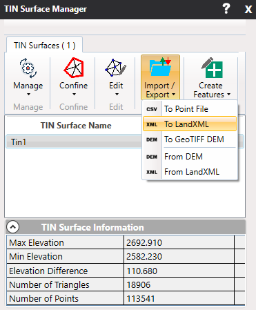
- Select the TIN surface you want to export from the TIN Surface Manager.
- Click the Import / Export tab.
- Choose To LandXML from the dropdown list.
- A Save File Dialog will appear.
- Enter a filename and select the .xml extension.
- Click Save.
Output Structure
The exported LandXML file includes:
- Surface name and metadata.
- Coordinate system (if defined).
- List of 3D points (vertices).
- Triangles forming the mesh.
Key Benefits
- Interoperability: Seamlessly used in Civil 3D, OpenRoads, Trimble Business Center, and more.
- Human-Readable: XML format is easy to validate or manipulate programmatically.
- Preserves Structure: Maintains triangulation and breakline data, not just points.
This tool is especially suited for workflows involving surface design reviews, regulatory submissions, or interoperability between survey/design systems.