Overview
The Point Group Manager in SPCAD is an intuitive and feature-rich interface for managing collections of CAD points—commonly used in surveying, surface modeling, and design workflows. Whether you’re organizing points, editing elevations, extracting from drawings, or exporting to standard GIS/CAD formats, this tool provides a streamlined experience in one place.
Key Components at a Glance
The top ribbon includes five main sections, each grouping key functionalities:
- Manage:
- Create new point groups, modify existing ones, or merge multiple groups into a single point group.
- Edit:
- Open a detailed Point Editor to modify point attributes.
- Use Change Elevation to apply bulk elevation transformations on all points in the point group.
- Add Points
- Populate point groups via:
- Manual selection from the drawing.
- Importing from external files.
- Drawing points on-screen.
- Extracting from CAD geometry like lines, arcs, and polylines.
- Sampling from raster surfaces such as DEMs.
- Populate point groups via:
- Export
- Export point data to:
- CSV/ASC/XYZ/TXT formats for interoperability.
- KML for viewing in tools like Google Earth. Shapefiles (SHP) for GIS applications.
- Export point data to:
- Create Features
- Derive new features from point data:
- ShrinkWrap boundary.
- Convex Hull around points.
- Quick Contours (elevation-based lines).
- Label as Soundings (elevation text based on IHO standards).
- As Tables (Create tables of point data).
- Derive new features from point data:
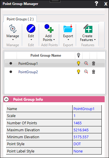
Point Groups Panel
At the top-left, the Point Groups (2) header displays the current number of point groups existing in the drawing. The panel below lists them with intuitive controls:
- Zoom – Focus the CAD view on the selected point group.
- Visibility Toggle – Turn the group display on or off.
- Delete – Remove the point group from the drawing and session.
Point Group Info Panel
When a point group is selected, detailed information is displayed below:
- Name, Scale, and Number of Points
- Elevation Statistics: Minimum and Maximum Elevations
- Point Style and Point Label Style