Purpose and Utility
The Download Web Map Tiles tool allows you to import high-resolution map tiles directly into your CAD drawing using SPCAD V25.1. These tiles add real-world background context to your CAD data, making your outputs more readable, spatially accurate, and visually meaningful. Whether you’re preparing a layout plan or need topographic reference, this tool helps integrate base maps from trusted web sources like Google, ESRI, and OpenStreetMap into your drawing environment.

This tool is particularly helpful when working on site planning, infrastructure layouts, and GIS-based CAD tasks where visual reference to roads, terrain, or satellite imagery is required.
Note: You must assign a valid projected coordinate system to your drawing before launching this tool.
Technical Description
- Requires a projected coordinate system to be assigned before use.
- Area can be defined in two ways:
- Draw a Window
- Select a closed Polygon
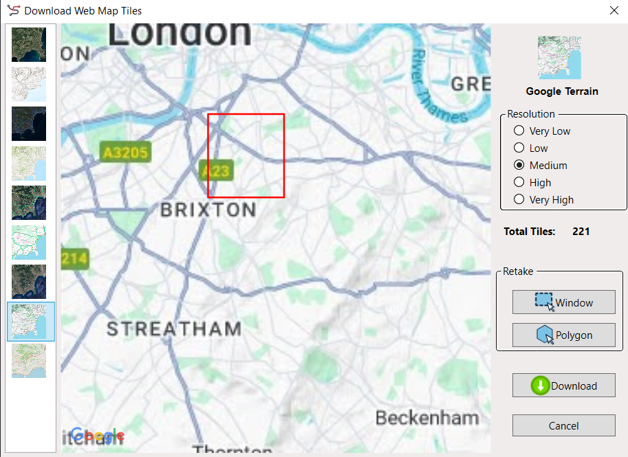
- Once area is selected, a dialog appears with the following options:
- Tile Source: ESRI, Google, or OpenStreetMap
- Resolution: Five levels — Very Low to Very High
- Live Preview: Shows the selected area with chosen tile style
- Retake Option: Redefine the area without restarting
- Output Folder & File Name: Must be specified before download
- After confirming settings, SPCAD performs:
- Downloading of tiles from the server
- Mosaicking to combine them into one image
- Clipping the mosaic to match the selected area
- A progress bar tracks the stages of download, mosaicking, and clipping. The tool enforces a download limit of 1000 tiles for trial users and 2000 for licensed users.
Workflow
1- Assign Coordinate System
Start by assigning a projected coordinate system to your drawing. Without it, the tiles cannot be positioned correctly.
2- Launch the Tool
To access the tool:
- Go to Coordinate System → Online Maps → Download Web Map Tiles
- Or type the command GNM_SP in the command line
3- Select Area to Fetch Tiles
You’ll be prompted to define the area for tile download. Two options are available:
- Window – Draw a rectangular area directly on your drawing
- Polygon – Select an already drawn closed polyline to fetch tiles within that shape
Once selected, the tool dialog opens.
Tile Source Options
In the dialog box, you’ll see a list of available basemap providers categorized as follows:

1- ESRI
- Aerial
- Shaded Relief
- Street Map
- Topographic
2- Google
- Hybrid
- Roadmap
- Satellite
- Terrain
3- OpenStreetMap
- Standard OSM map view
As you make your selection, a live map view in the center of the dialog updates in real time to reflect your area and chosen source.
Resolution Settings
There are 5 levels of resolution available:
- Very Low
- Low
- Medium
- High
- Very High
Higher resolutions result in more tiles and longer download times. The Total Tiles counter updates as you adjust resolution or area.

Retake Options
If you’re not satisfied with your area selection, use the Retake section:
- Redraw the area using Window, or
- Choose another Polygon
This ensures you have full control over what you’re about to fetch.

Download Tiles
Before clicking Download, select an output folder and assign a clear name for your tiles.
For each tile downloaded, SPCAD generates three files:
- .png image
- .xml metadata
- .pgw georeferencing file

Make sure your file name is easy to identify later, especially if downloading in parts.
Download Process
Once you hit Download, SPCAD performs the following:
- Fetches the tiles
- Mosaics them into a single image
- Clips the image to match your selected area
You’ll see a progress bar as each step completes.

Performance & Limits
- The more tiles, the longer the wait.
- You can cancel anytime and retry with a lower resolution.
- Licensed users can download up to 2000 tiles per session
- Trial users are limited to 1000 tiles
For larger areas, divide your drawing and fetch tiles in smaller sections.
After downloading in parts, use the Mosaic Images (MOSAIC_SP) tool to combine everything into a single clean image without overloading your drawing.
Notes
- Works only with projected coordinate systems.
- Ideal for layout plans, base maps, terrain references, or any spatial design task where visual context is required.
Tips
- To reduce tile count and processing time, use medium resolution for larger extents and high resolution for zoomed-in areas.
- Make use of the Retake option to refine your area selection without restarting.
- Use Mosaic Images tool post-download for efficient tile management and cleaner drawings.